Hiking in Ontario Canada
Algonquin Park & Area Trails
A guide to hiking trails in Algonquin Park, Ontario & Area
Tips for hiking in the various seasons.
Spring
- Wear comfortable hiking boots. Some trail conditions may be icy. "Icers" or similar footwear attachments are recommended on some early Spring hikes.In icy conditions, hiking poles may also be used. The trails may become very wet once the thaw is in full swing.
- Dress in layers..
- Bring lunch & snacks for longer hikes.
- Wear a hat and sunscreen.
- Bring at least 1 liter of water and a hot drink if it's cool.
Tips for Summer Hikes
- Wear comfortable hiking boots, hat, sunscreen as well as mosquito repellant.
- Bring lunch & snacks for longer hikes.
- Bring plenty to drink - 2 liter or more of water on a warm days.
Tips for Autumn Hikes
- Wear comfortable hiking boots.
- Dress in layers.
- Bring lunch & snacks for longer hikes.
- Wear a hat and sunscreen.
- Bring at least 1 liter of water and a hot drink if it's cool.
Tips for Winter Hikes
- Wear comfortable hiking boots. Some winter trail conditions may be icy. "Icers" or similar footwear attachments should be used on some Winter and early Spring hikes where ice tends to build up on the trails. In icy conditions, hiking poles may also be used. Snowshoes make hiking through heavy snow easier.
- Dress in layers.
- Bring lunch & snacks for longer hikes.
- Bring water and a hot drink.
The Couples Resort Hiking Trails
On-site scenic hiking trails, leading to a lookout over Algonquin Park, consisting of three loops, Lookout Trail 1.0 km in length, Bear trail loop 2.7 and Rail Line loop 1.2
Available for use, 12 sets of 100% waterproof / breathable four season outer garment gear.
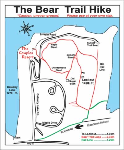
Click for Detail PDF of Hiking Trails
Day Trails - Algonquin Park
Whiskey Rapids
(at km 7.2) This trail is a 2.1 km loop leading along the Oxtongue River to scenic Whiskey Rapids. The trail guide discusses the ecology and history of an Algonquin river.
Hardwood Lookout
(at km 13.8) This 0.8 km walk introduces you to the ecology of a typical Algonquin hardwood forest and culminates in a fine view of Smoke Lake and the surrounding hills.
Mizzy Lake
(at km 15.4) This 11 km trail requires an early start and a full day to do properly. It visits nine ponds and small lakes and affords some of the best chances to see wildlife in the Parkway Corridor.
Peck Lake
(at km 19.2) The Peck Lake Trail is 1.9 km long and goes completely around the shoreline of Peck Lake. The trail guide explores the ecology of a typical Algonquin lake.
Track & Tower
(at km 25) A 7.7 km loop featuring a spectacular lookout over Cache Lake, this trail introduces you to some fascinating history. A 5.5 km optional side trip follows an abandoned railway to Mew Lake.
Hemlock Bluff
(at km 27.2) This 3.5 km loop leads through mixed forest to an impressive view of Jack Lake. The guide presents results of research in Algonquin.
Bat Lake
(at km 30) The 5.5 km of this trail passes through hardwood and coniferous forest including a large hemlock grove. General Algonquin ecology is discussed in the trail guide.
Two Rivers
(at km 31) This 2 km loop includes an easy ascent to a pine-clad cliff and introduces the importance of change in the natural forests of Algonquin.
Centennial Ridges
(2 km south from km 37.6) This very demanding 10 km loop affords spectacular viewing along two high ridges. The guide discusses contributions of selected people to the Park over its first century.
Lookout
(at km 39.7) This 1.9 km loop is a fairly steep and rugged trail which rewards the hiker with a magnificent view of several hundred square kilometres of Algonquin. The trail guide discusses the geology of the Park.
Booth's Rock
(8 km south from km 40.3) This 5.1 km loop visits two lakes and a spectacular lookout, returning via an abandoned railway while the guide discusses human impact on the Park.
Big Pines
(at km 40.3) This 2.9 km loop visits about 80 huge, old White Pines and the site of an 1880s logging camp. The guide discusses how these magnificent trees came to be there, pine ecology, and the Park's logging history.
Spruce Bog
(at km 42.5)
Wheelchair accessible
Several boardwalk sections in this 1.5 km loop give you an excellent close-up look of two typical northern spruce bogs. The guide discusses their ecology.
Beaver Pond
(at km 45.2) A 2 km loop yields excellent views of two beaver ponds while the guide provides an introduction to Algonquin's fascinating beaver ecology.
Berm Lake
(at Achray Campground) on the Park's East Side This beautiful 4.5 km trail loops through Algonquin's pine forests so typical on the Park's east side. The trail guide introduces you to pine forest ecology.
Barron Canyon
(11 km past Sand Lake Gate) on the Park's East Side This 1.4 km loop leads along the rim of the Park's most breathtaking river gorge. The history and ecology of the canyon is discussed in the trail guide.
Brent Crater
(32 km from Hwy 17 on Brent Road) on the North end of the Park From an observation tower, this 2 km loop explores the eroded wall of an ancient meteorite crater. The history and ecology of the crater is the theme of the trail guide.
